"The Force of Nature in Mexico, as seen from space"
World Space Week 2015 Exhibition
During the 2015 World Space Week, the UN Office for Outer Space Affairs hosted an exhibition by the Mexican Space Agency in the Rotunda of the Vienna International Centre entitled "The Force of Nature in Mexico, as seen from space".
The Mexican Space Agency, in cooperation with governmental entities specialized in disaster management, developed a series of 20 panels featuring how Earth observation is used in disaster management. Some panels illustrate some of the main disasters in Mexico, i.e. floods, hurricanes, and forest fires, along with their case studies.
UNOOSA wishes to thank the Mexican Space Agency for permitting us to post a copy of these panels here so that they might be enjoyed by people throughout the world.
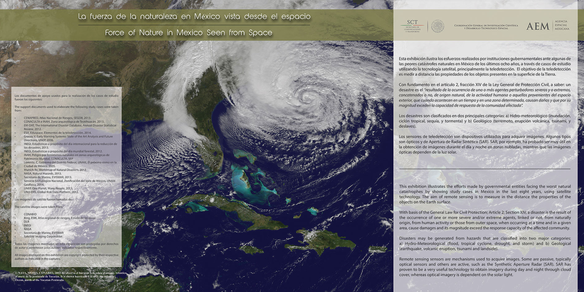
This exhibition illustrates the efforts made by governmental entities facing the worst natural catastrophes by showing study cases in Mexico in the last eight years, using satellite technology. The aim of remote sensing is to measure in the distance the properties of the objects on the Earth surface.
With basis of the General Law for Civil Protection; Article 2; Section XIV, a disaster is the result of the occurrence of one or more severe and/or extreme agents, linked or not, from naturally origin, from human activity or those from outer space, when occurring at a time and in a given area, cause damages and its magnitude exceed the response capacity of the affected community.
Disasters may be generated from hazards that are classified into two major categories: a) Hydro-Meteorological (flood, tropical cyclone, drought, and storm) and b) Geological (earthquake, volcanic eruption, tsunami and landside).
Remote sensing sensors are mechanisms used to acquire images. Some are passive, typically optical sensors and others are active, such as the Synthetic Aperture Radar (SAR). SAR has proven to be a very useful technology to obtain imagery during day and night through cloud cover, whereas optical imagery is dependent on the solar light.
DISASTERS WORLDWIDE
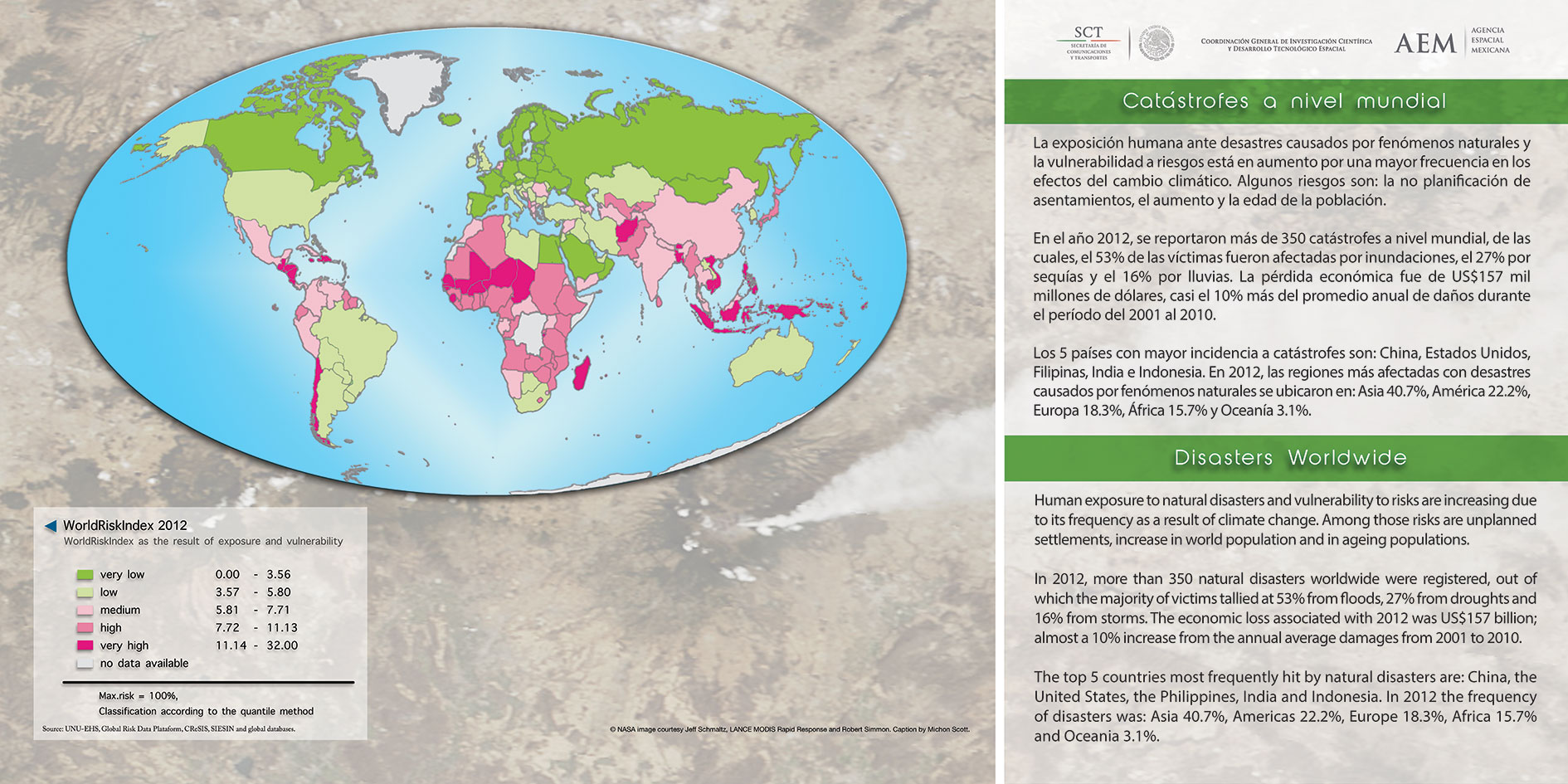
Human exposure to natural disasters and vulnerability to risks are increasing due to its frequency as a result of climate change. Among those risks are unplanned settlements, increase in world population and in ageing populations.
In 2012, more than 350 natural disasters worldwide were registered, out of which the majority of victims tallied at 53./ofrom floods, 27% from droughts and 16% from storms. The economic loss associated with 2012 was US$157 billion; almost a 10% increase from the annual average damages from 2001 to 2010.
The top 5 countries most frequently hit by natural disasters are: China, the United States, the Philippines, India and Indonesia. In 2012 the frequency of disasters was: Asia 40.7%, Americas 22.2%, Europe 18.3%, Africa 15.7% and Oceania 3.1%.
MEXICO A VULNERABLE COUNTRY
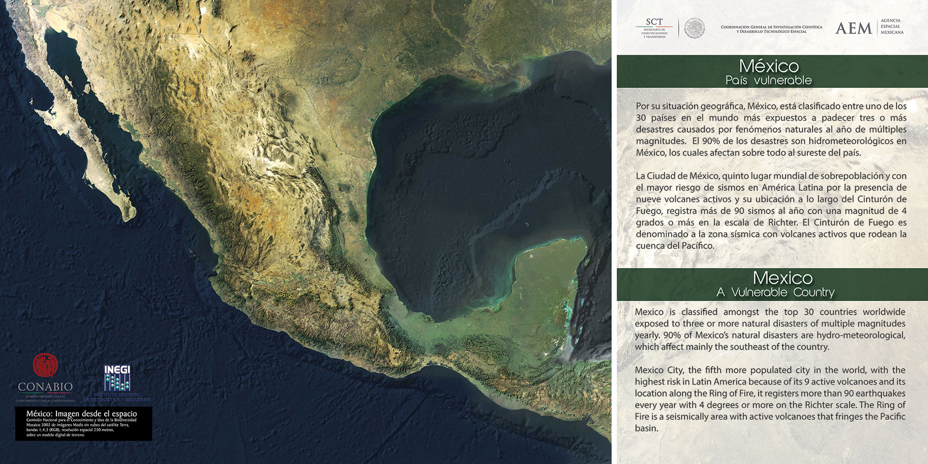
Mexico is classified amongst the top 30 countries worldwide exposed to three or more natural disasters of multiple magnitudes yearly. 90% of Mexico's natural disasters are hydro-meteorological, which affect mainly the southeast of the country.
Mexico City, the fifth more populated city in the world, with the highest risk in Latin America because of its 9 active volcanoes and its location along the Ring of Fire, it registers more than 90 earthquakes every year with 4 degrees or more on the Richter scale. The Ring of Fire is a seismically area with active volcanoes that fringes the Pacific basin.
HURRICANES, TROPICAL STORMS AND FLOODS
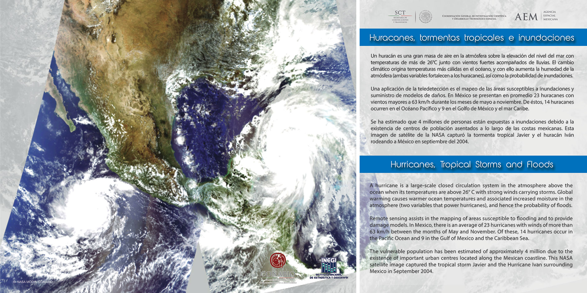
A hurricane is a large-scale closed circulation system in the atmosphere above the ocean when its temperatures are above 26° C with strong winds carrying storms. Global warming causes warmer ocean temperatures and associated increased moisture in the atmosphere (two variables that power hurricanes), and hence the probability of floods.
Remote sensing assists in the mapping of areas susceptible to flooding and to provide damage models. In Mexico, there is an average of 23 hurricanes with winds of more than 63 km/h between the months of May and November. Of these, 14 hurricanes occur in the Pacific Ocean and 9 in the Gulf of Mexico and the Caribbean Sea.
The vulnerable population has been estimated of approximately 4 million due to the existence of important urban centres located along the Mexican coastline. This NASA satellite image captured the tropical storm Javier and the Hurricane Ivan surrounding Mexico in September 2004.
OVERFLOW OF THE PAPAGAYO RIVER, GUERRERO
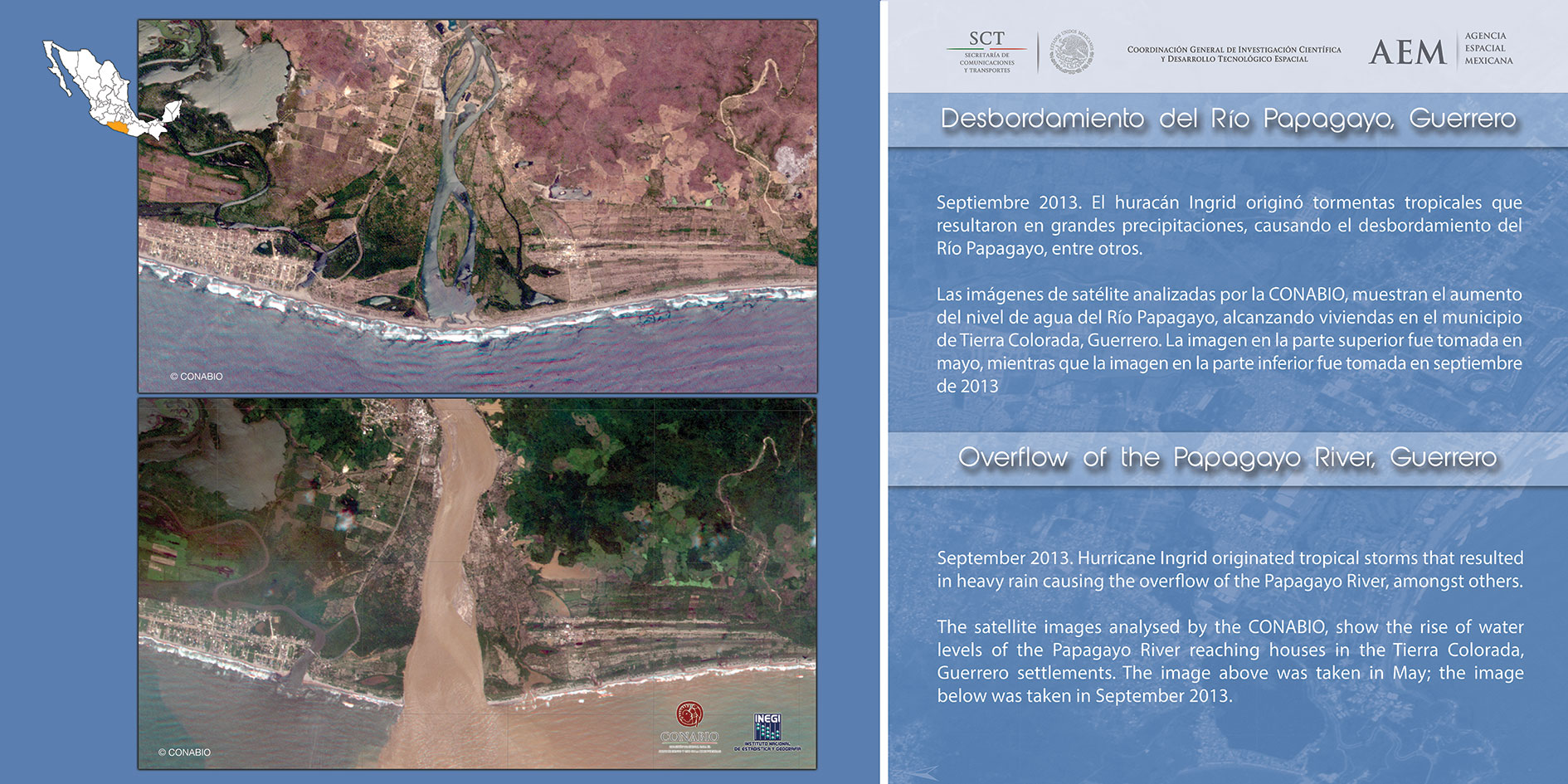
September 2013. Hurricane Ingrid originated tropical storms that resulted in heavy rain causing the overflow of the Papagayo River, amongst others.
The satellite images analysed by the CONABIO, show the rise of water levels of the Papagayo River reaching houses in the Tierra Colorada, Guerrero settlements. The image above was taken in May; the image below was taken in September 2013.
FLOODS IN GUERRERO
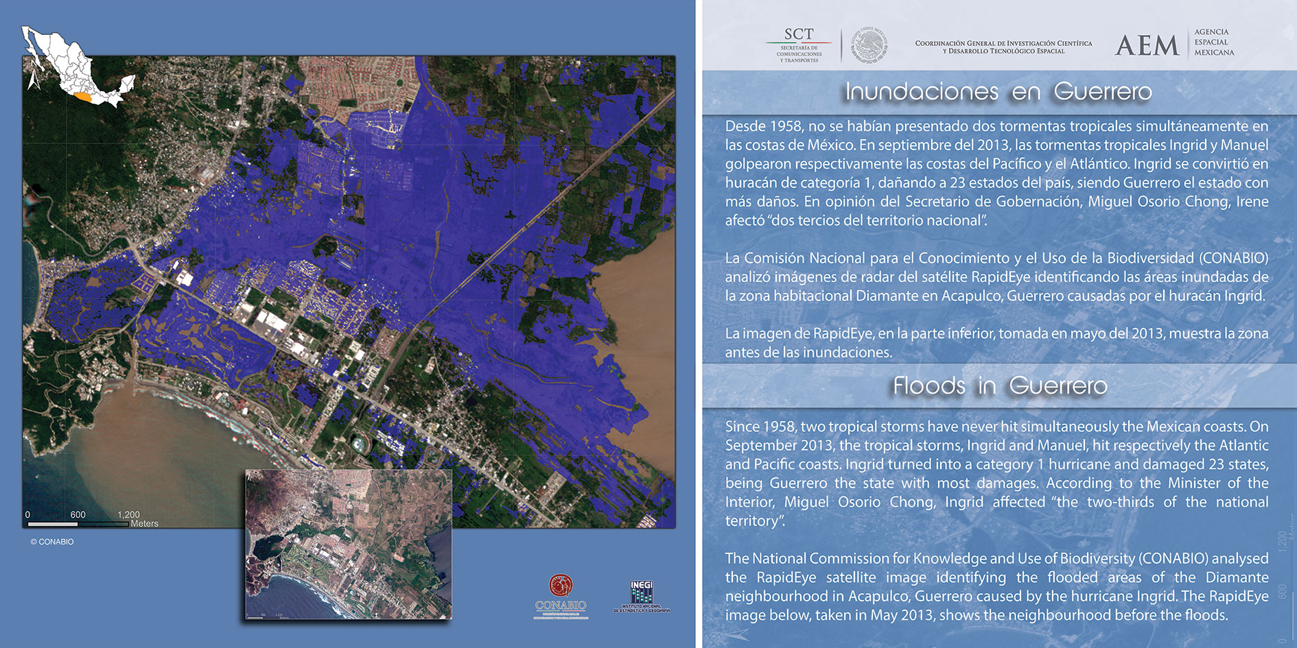
Since 1958, two tropical storms have never hit simultaneously the Mexican coasts. On September 2013, the tropical storms, Ingrid and Manuel, hit respectively the Atlantic and Pacific coasts. Ingrid turned into a category 1 hurricane and damaged 23 states, being Guerrero the state with most damages. According to the Minister of the Interior, Miguel Osorio Chong, Ingrid affected "the two-thirds of the national territory".
The National Commission for Knowledge and Use of Biodiversity (CONABIO) analysed the RapidEye satellite image identifying the flooded areas of the Diamante neighbourhood in Acapulco, Guerrero caused by the hurricane Ingrid. The RapidEye image below, taken in May 2013, shows the neighbourhood before the floods.
FLOOD IN TABASCO
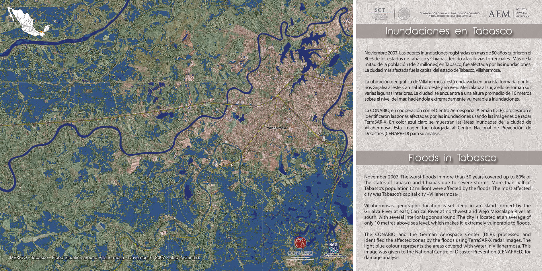
November 2007. The worst floods in more than 50 years covered up to 80% of the states of Tabasco and Chiapas due to severe states. More than half of Tabasco's population (2 million) were affected by the floods. The most affected city was Tabasco's capital city -Villahermosa-.
Villahermosa's geographic location is set deep in an island formed by the Grijalva River at east, Carrizal River at northwest and Viejo Mezcalapa River at south, with several interior lagoons around. The city is located at an average of only 10 metres above sea level, shah makes it extremely vulnerable to floods.
The CONABIO and the German Aerospace Center (DLR), processed and identified the affected zones by the floods using TerraSAR-X radar images. The light blue colour represents the areas covered with water in Villahermosa. This image was given to the National Centre of Disaster Prevention (CENAPRED) for damage analysis.
FOREST FIRES
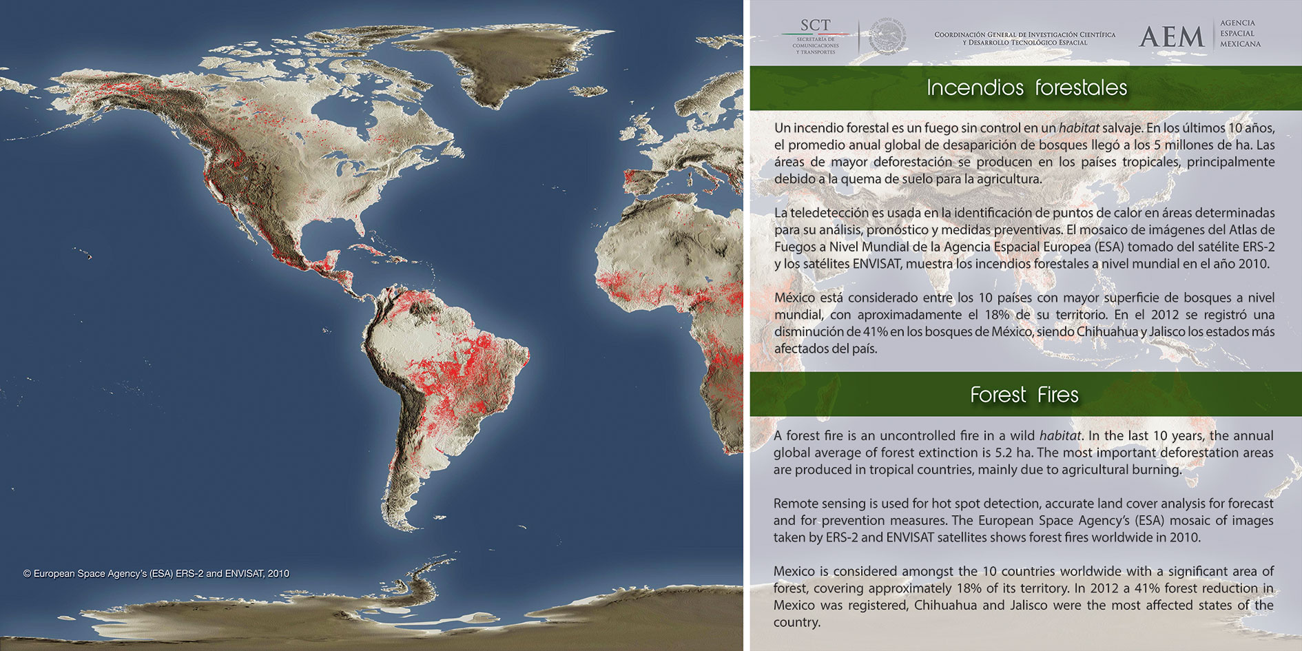
A forest fire is an uncontrolled fire in a wild habitat. In the last 10 years, the annual global average of forest extinction is 5.2 ha. The most important deforestation areas are produced in tropical countries, mainly due to agricultural burning.
Remote sensing is used for hot spot detection, accurate land cover analysis for forecast and for prevention measures. The European Space Agency's (ESA) mosaic of images taken by ERS-2 and ENVISAT satellites shows forest fires worldwide in 2010.
Mexico is considered amongst the 10 countries worldwide with a significant area of forest, covering approximately 18% of its territory. In 2012 a 41% forest reduction in Mexico was registered, Chihuahua and Jalisco were the most affected states of the country.
FOREST FIRE IN JALISCO
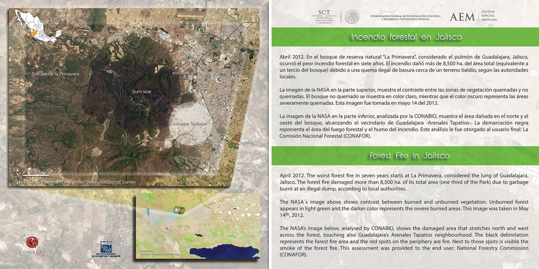
April 2012. The worst forest fire in seven years starts at La Primavera, considered the lung of Guadalajara, Jalisco. The forest fire damaged more than 8,500 ha. of its total area (one third of the Park) due to garbage burnt at an illegal dump, according to local authorities.
The NASA's image above shows contrast between burned and unburned vegetation. Unburned forest appears in light green and the darker color represents the severe burned areas. This image was taken in May 14th, 2012.
The NASA's image below, analysed by CONABIO, shows the damaged area that stretches north and west across the forest, touching also Guadalajara's Arenales Tapatios neighbourhood. The black delimitation represents the forest fire area and the red spots on the periphery are fire. Next to those spots is visible the smoke of the forest fire. This assessment was provided to the end user: National Forestry Commission (CONAFOR).
POPOCATEPETL "THE SMOKING MOUNTAIN"
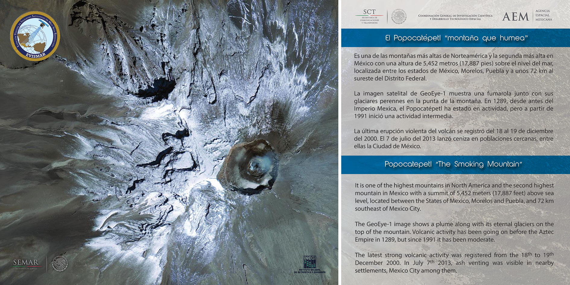
It is one of the highest mountains in North America and the second highest mountain in Mexico with a summit of 5,452 meters (17,887 feet) above sea level, located between the States of Mexico, Morelos and Puebla, and 72 km southeast of Mexico City.
The GeoEye-1 image shows a plume along with its eternal glaciers on the top of the mountain. Volcanic activity has been going on before the Aztec Empire in 1289, but since 1991 it has been moderate.
The latest strong volcanic activity was registered from the 18th to 19th December 2000. In July 7th 2013, ash venting was visible in nearby settlements, Mexico City among them.
AGRICULTURE AT RISK
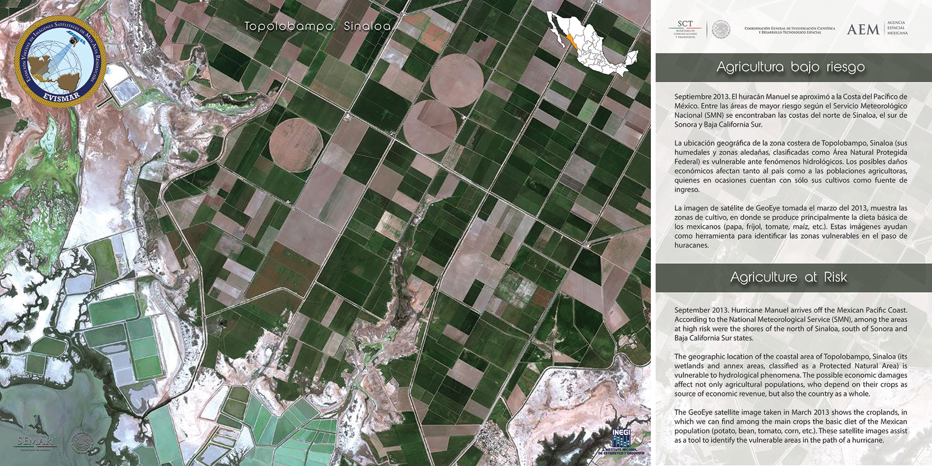
September 2013. Hurricane Manuel arrives off the Mexican Pacific Coast. According to the National Meteorological Service (SMN), among the areas at high risk were the shores of the north of Sinaloa, south of Sonora and Baja California Sur states.
The geographic location of the coastal area of Topolobampo, Sinaloa (its wetlands and annex areas, classified as a Protected Natural Area) is vulnerable to hydrological phenomena. The possible economic damages affect not only agricultural populations, who depend on their crops as source of economic revenue, but also the country as a whole.
The GeoEye satellite image taken in March 2013 shows the croplands, in which we can find among the main crops the basic diet of the Mexican population (potato, bean, tomato, corn, etc.). These satellite images assist as a tool to identify the vulnerable areas in the path of a hurricane.
FLOODS IN VERACRUZ
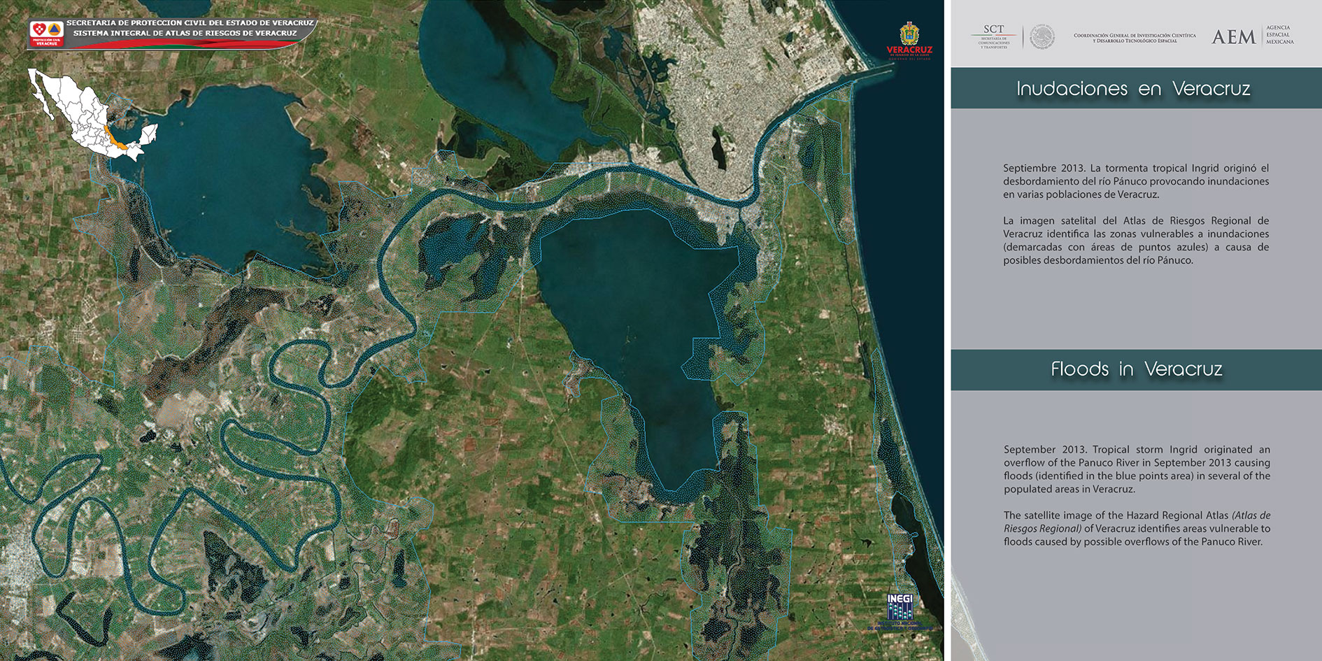
September 2013. Tropical storm Ingrid originated an overflow of the Pam. River in September 2013 causing floods (identified in the blue points area) in several of the populated areas in Veracruz.
The satellite image of the Hazard Fiegional Atlas (Atlas de Riesgos Regional) of Veracruz identifies areas vulnerable to floods caused by possible overflows of the Panuco River.
TEOTIHUACAN "the place where the gods were created"
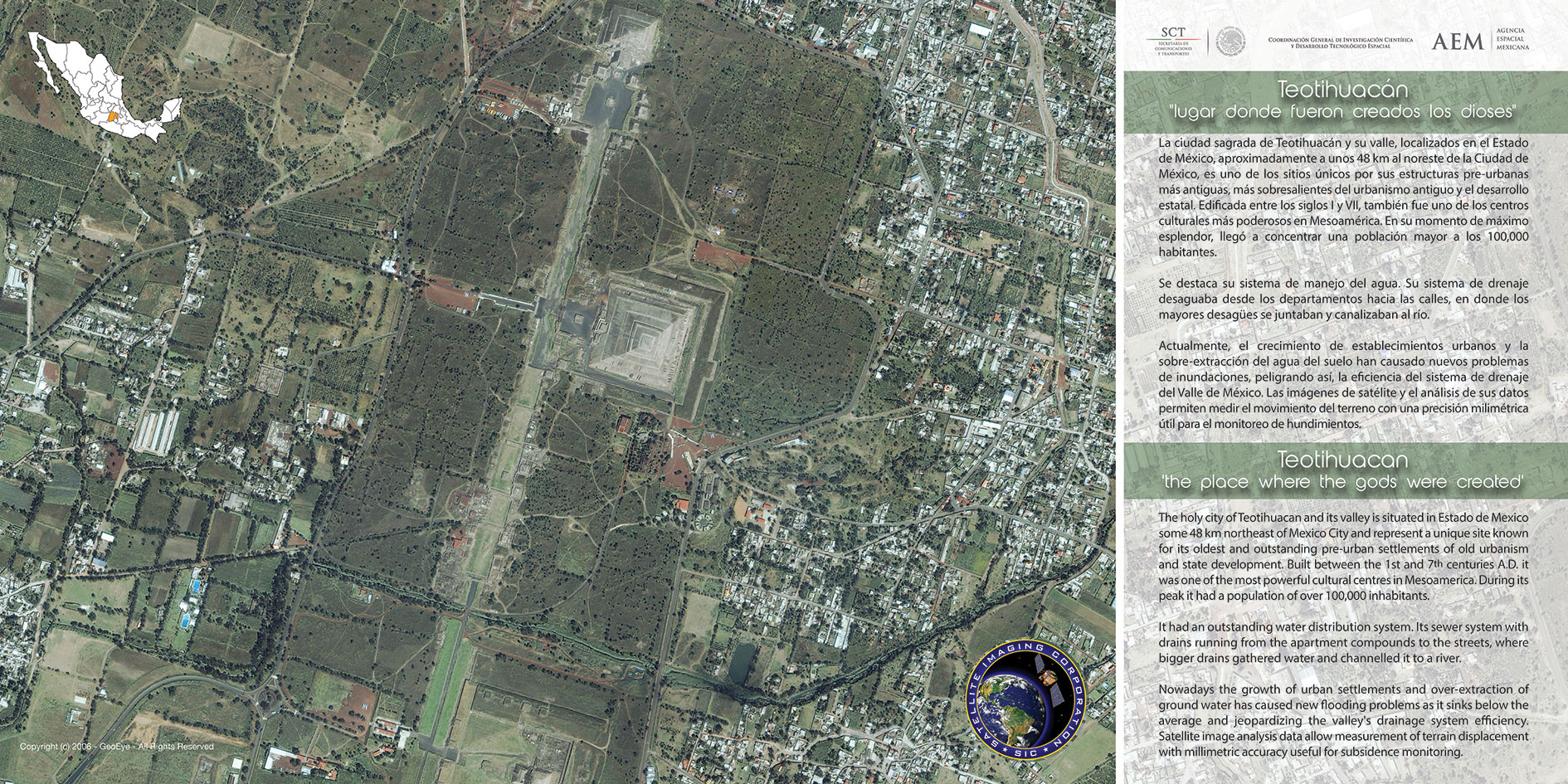
The holy city of Teotihuacan and its valley is situated in Estado de Mexico some 48 km northeast of Mexico City and represent a unique site known for its oldest and outstanding pre-urban settlements of old urbanism and state development. Built between the 1st and 7,1) centuries A.D. it was one of the most powerful cultural centres in Mesoamerica. During its peak it had a population of over 100,000 inhabitants.
It had an outstanding water distribution system. Its sewer system with drains running from the apartment compounds to the streets, where bigger drains gathered water and channelled it to a river.
Nowadays the growth of urban settlements and over-extraction of ground water has caused new flooding problems as it sinks below the average and jeopardizing the valley's drainage system efficiency. Satellite image analysis data allow measurement of terrain displacement with millimetric accuracy useful for subsidence monitoring.
MEXICO CITY'S SUBSIDENCE
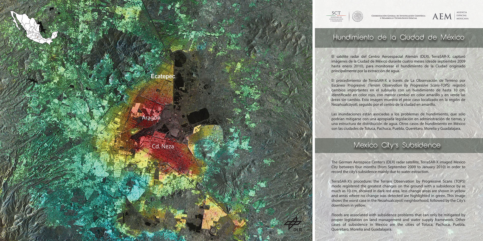
The German Aerospace Center's (DLR) radar satellite, TerraSAR-X imaged Mexico City between four months (from September 2009 to January 2010) in order to record the city, subsidence mainly due to water extraction.
TerraSAR-X's procedure: the Terrain Observation by Progressive Scans (TOPS) mode registered the greatest changes on the ground with a subsidence by as much as 10 cm. showed in dark red area, less change areas are shown in yellow and areas where no change was detected are highlighted in green. This image shows the worst case in the Nezahualcoyotl neighborhood, followed by the City's downtown in yellow.
Floods are associated with subsidence problems that can only be mitigated by proper legislation on land management and water supply framework. Other cases of subsidence in Mexico are the cities of Toluca, Pachuca, Puebla, Queretaro, Morelia and Guadalajara.
THE CENAPRED NATIONAL HAZARDS ATLAS SYSTEM
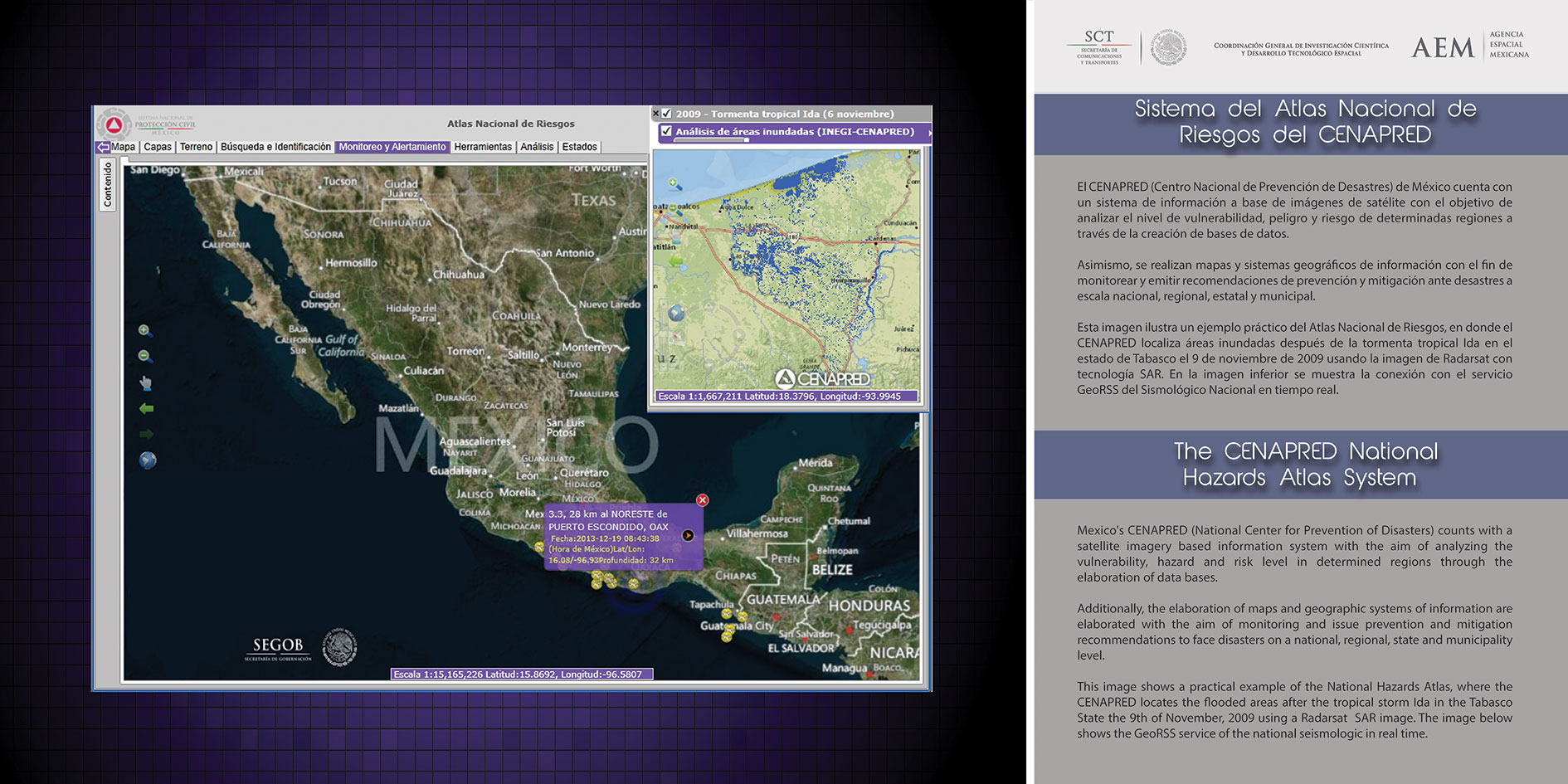
Mexico's CENAPRED (National Center for Prevention of Disasters) counts with a satellite imagery based information system with the aim of analyzing the vulnerability, hazard and risk level in determined regions through the elaboration of data bases.
Additionally, the elaboration of maps and geographic systems of information are elaborated with the aim of monitoring and issue prevention and mitigation recommendations to face disasters on a national, regional, state and municipality level.
This image shows a practical example of the National Hazards Atlas, where the CENAPRED locates the flooded areas after the tropical storm Ida in the Tabasco State the 9th of November, 2009 using a Radarsat SAR image. The image below shows the GeoRSS service of the national seismologic in real time.
PROPOSAL OF A NATIONAL SATELLITE EARLY WARNING SYSTEM
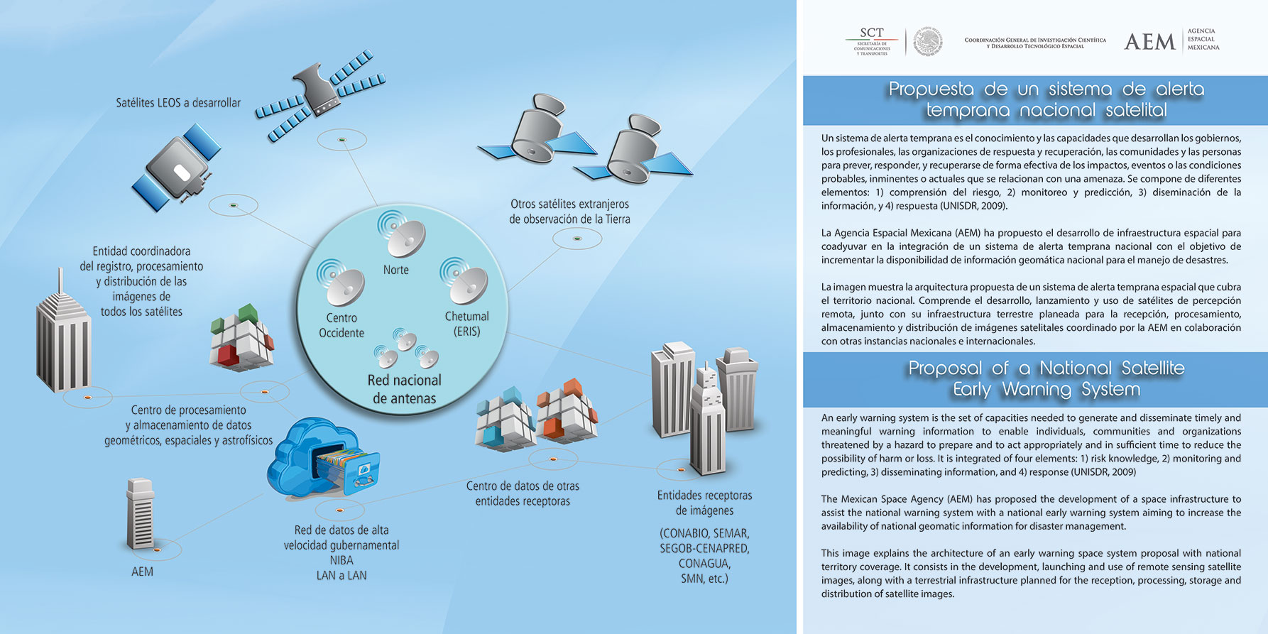
An early warning system is the set of capacities needed to generate and disseminate timely and meaningful warning information to enable individuals, communities and organizations threatened by a hazard to prepare and to act appropriately and in sufficient time to reduce the possibility of harm or loss. It is integrated of four elements: 1) risk knowledge, 2) monitoring and predicting, 3) disseminating information, and at response (UNISDR, 2009)
The Mexican Space Agency (OEM) has proposed the development of a space infrastructure to assist the national warning system with a national early warning system aiming to increase the availability of national geomatic information for disaster management.
This image explains the architecture of an early warning space system proposal with national territory coverage. It consists in the development, launching and use of remote sensing satellite images, along with a terrestrial infrastructure planned for the reception, processing, storage and distribution of satellite images.
MEXICO CITY AND ITS SURROUNDINGS FACING EARTHQUAKES
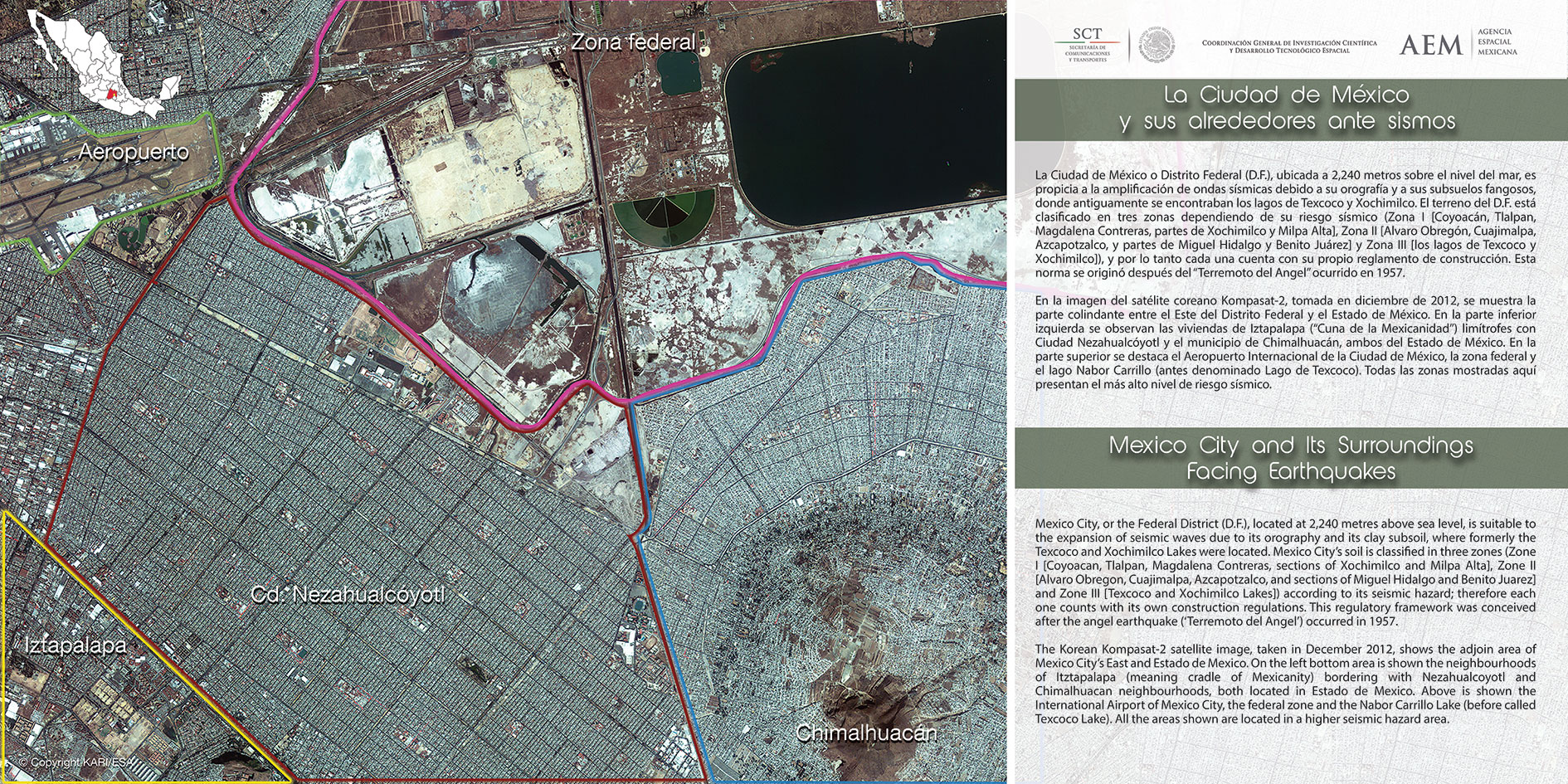
Mexico City, or the Federal District (D.F.), located at 2,240 metres above sea )evel, is suitable to the expansion of seismic waves due to its orography and its clay subsoil, where formerly the Texcoco and Xochimilco Lakes were located. Mexico City's soil is classified in three zones (Zone I [Coyoacan, Tlalpan, Magdalena Contreras, sections of Xochimilco and Milpa Alta], Zone II [Alvaro Obregon, Cuajimalpa, Azcapotzalco, and sections of Miguel Hidalgo and Benito Juarez] and Zone III [Texcoco and Xochimilco Lakes]) according to its seismic hazard; therefore each one counts with its own construction regulations. This regulatory framework was conceived after the angel earthquake ('Terremoto del Angel') occurred in 1957.
The Korean Kompasat-2 satellite image, taken in December 2012, shows the adjoin area of Mexico City's East and Estado de Mexico. On the left bottom area is shown the neighbourhoods of Itztapalapa (meaning cradle of Mexicanity) bordering with Nezahualcoyotl and Chimalhuacan neighbourhoods, both located in Estado de Mexico. Above is shown the International Airport of Mexico City, the federal zone and the Nabor Carrillo Lake (before called Texcoco Lake). All the areas shown are located in a higher seismic hazard area.
WORLD HERITAGE SITES AND ITS EXPOSURE TO NATURAL PHENOMENA
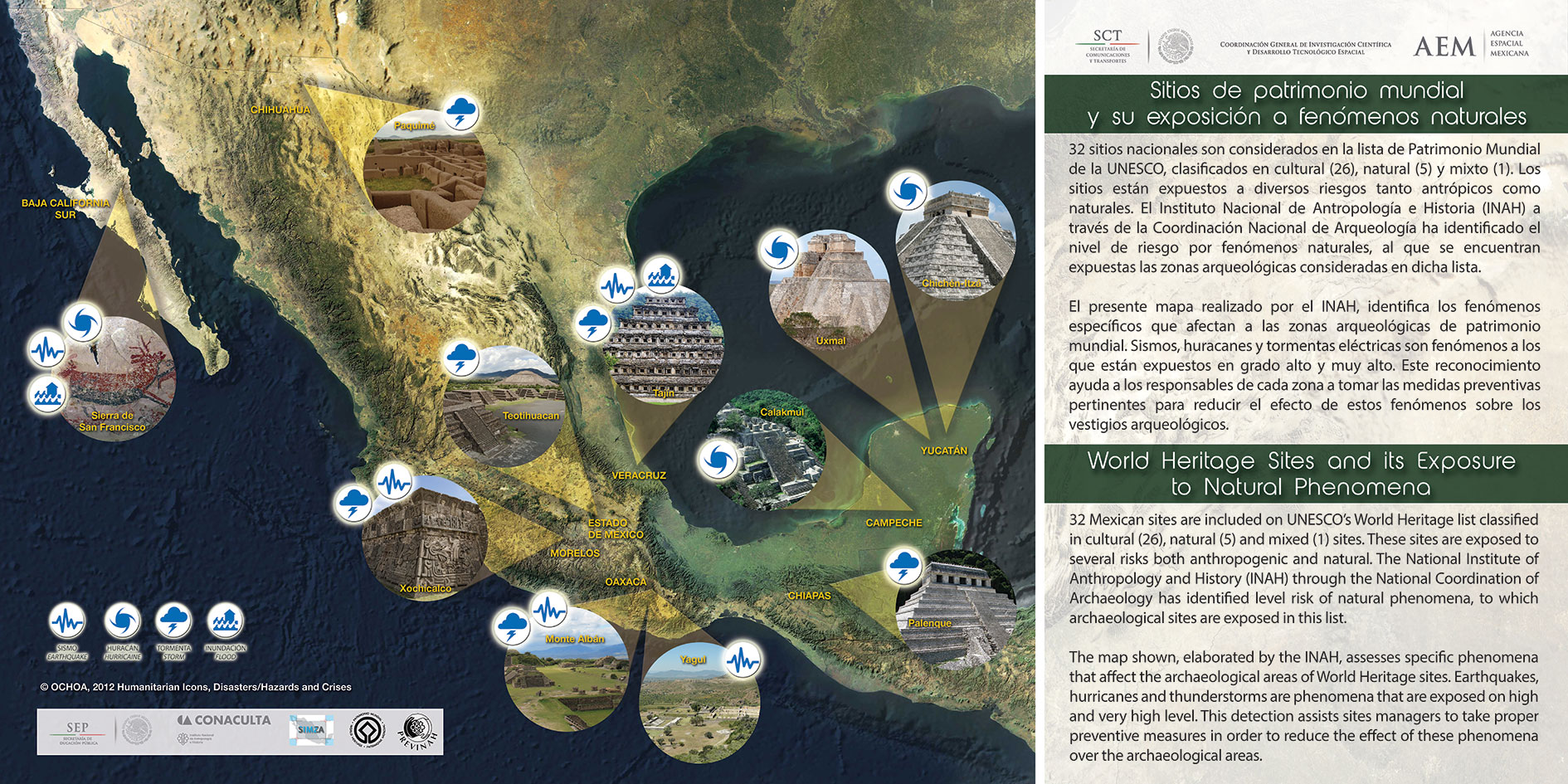
32 Mexican sites are included on UNESCO's World Heritage list classified in cultural (26), natural (5) and mixed (1) sites. These sites are exposed to several risks both anthropogenic and natural. The National Institute of Anthropology and History (INAH) through the National Coordination of Archaeology has identified level risk of natural phenomena, to which archaeological sites are exposed in this list.
The map shown, elaborated by the INAH, assesses specific phenomena that affect the archaeological areas of World Heritage sites. Earthquakes, hurricanes and thunderstorms are phenomena that are exposed on high and very high level. This detection assists sites managers to take proper preventive measures in order to reduce the effect of these phenomena over the archaeological areas.
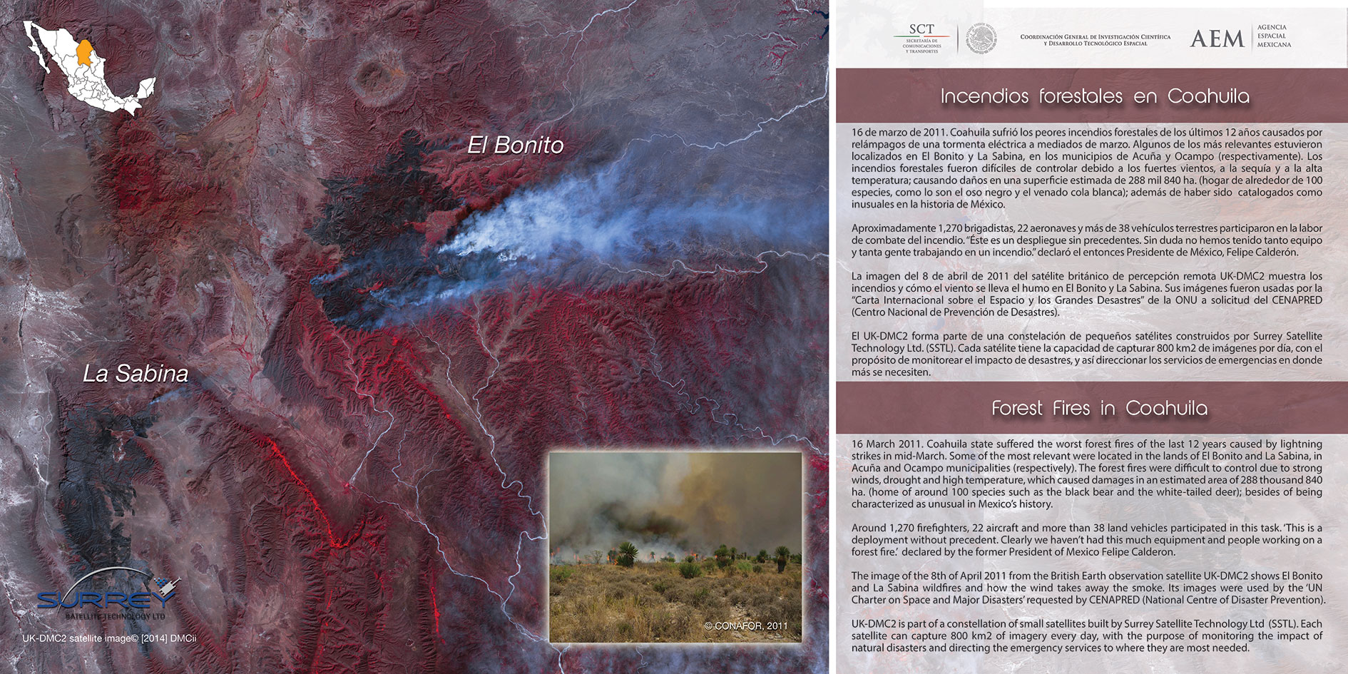
FOREST FIRES IN COAHUILA
16 March 2011. Coahuila state suffered the worst forest fires of the last 12 years caused by lightning strikes in mid-March. Some of the most relevant were located in the lands of El Bonito and La Sabina, in Acuria and Ocarnpo municipalities (respectively). The forest fires were difficult to control due to strong winds, drought and high temperature, which caused damages in an estimated area of 288 thousand 840 ha. (home of around 100 species such as the black bear and the white-tailed deer); besides of being characterized as unusual in Mexico, history. Around 1,270 firefighters, 22 aircraft and more than 38 land vehicles participated in this task.'This is a deployment without precedent. Clearly we haven't had this much equipment and people working on a forest fire: declared by the former President of Mexico Felipe Calderon. The image of the 8th of April 2011 from the British Earth observation satellite UK-DMC2 shows El Bonito and La Sabina wildfires and how the wind takes away the smoke. Its images were used by the 'UN Charter on Space and Major Disasters' requested by CENAPRED (National Centre of Disaster Prevention). UK-DMC2 is part of a constellation of small satellites built by Surrey Satellite Technology Ltd (SSTL). Each satellite can capture 800 km2 of imagery every day, with the purpose of monitoring the impact of natural disasters and directing the emergency services to where they are most needed.