Inputs to UN-Space publication 2022: FAO contribution to UN-Space publication
General
The Food and Agriculture Organization of the United Nations (FAO) is an agency of the United Nations organization with 194 Member Nations, established in 1945 and headquartered in Rome, Italy, that leads international efforts to defeat hunger. Serving both developed and developing countries, FAO acts as a neutral forum where all nations meet as equals to negotiate agreements and debate policy. FAO provides support to countries to achieve the Sustainable Development Goals (SDG). FAO is the custodian UN agency for 21 SDG indicators and is a contributing agency for a further 5. In this capacity, FAO is supporting countries' efforts in monitoring the 2030 Agenda.
FAO is a large user of Earth Observing (EO) satellite and space-based telecommunications and guidance systems data and services. Communications and Geostationary EO satellites, especially weather and disaster modelling and prediction systems, are crucial to understanding the Earth system. FAO supports, develops, and uses geospatial data, methods, and tools, which are applied to national, regional and global sustainable development planning and implementation. FAO helps countries to implement appropriate geospatial solutions, that can assist their efforts to create sustainable food systems. This work is organized and delivered through projects and programs carried out both at HQ and regional, sub-regional, and national offices, in close collaboration with the UN Agencies, to ensure that best practices and standards are adopted and implemented.
Since its origin, FAO develops and uses geospatial methods and tools for sustainable natural resources monitoring. The Geospatial Unit in the Land and Water Division (NSL) supports the adoption of geospatial solutions that are customized to in-country needs compliant with international standards. The Digitalization and Informatics Division (CSI) provides technical solutions on Geospatial to strengthen data sharing and accessibility such as data repository for country owned geospatial data sets to support member countries' institutional memory and to improve data and information accessibility. The Forestry Division (NFO) develops and provides free and open-source software and related capacity development. The Open Foris initiative, established in 2011, contains tools that allow accurate field data collection, augmented visual interpretation of satellite images as well as efficient cloud-based processing of large remote sensing data archives. Some open Foris tools have also been integrated with Google Earth Engine to allow access to Google´s on-the-fly processing capability and extensive geospatial data archives. Over the last years, FAO has empowered more than 35,000 experts in 180 countries to collect, analyze and report data and information on natural resources and their changes. Now, as part of the FAO Hand in Hand Initiative, FAO is using a Geospatial Information Technology to collect and analyze, using innovative Artificial intelligence and Machine Learning approaches (e.g., Google Eart Engine, SEPAL), all available data from within the organization and other agencies and brings geospatial data such as its high-resolution soil, water, forestry, environmental, animal production, pest and diseases, road network, crop areas, and crop calendar data.
There are several geo-referenced information systems and databases across the FAO departments/ divisions and several information portals and databases that report on Agriculture, Rural Development and Food Security at FAO that provide information, both spatial and non-spatial. FAO's geospatial products and support are delivered by several specialized technical teams through extra budgetary projects and regular program activities. FAO is responsible for supporting member countries in their efforts to generate better locally or nationally owned data and information for national policy formulation and decision making. FAO also generates and hosts several global FAO datasets, which serve the public, international organizations, government agencies, research institutions, academia and non-governmental organizations.
FAO's geospatial analytical capacities, modelling frameworks, tools and systems for monitoring and forecasting are world-renowned and information from the array of systems developed to date is widely acknowledged as ground-breaking in their extent and innovative nature. The development of FAO geospatial capabilities requires close collaboration between geospatial, statistical, technical unit and IT capacities. FAO benefits from space-related technologies to support sustainable development and technical capacities such as in realm of emergency response, disaster preparedness, agricultural, forestry, fishery and environmental resources monitoring, land cover, land use, agro-ecological zoning, water, biodiversity, climate change, and agrifood system digital transformation.
Links:
- https://www.fao.org/home/en
- https://www.fao.org/geospatial/en/
- ca3237en.pdf (fao.org)
- https://www.fao.org/hand-in-hand/en
- https://www.fao.org/sustainable-development-goals/indicators/en/
- https://openforis.org/
- https://sepal.io/
Highlights
The Environmental Technical Working Group in Cox's Bazar, Bangladesh, benefits from space-related technologies for landscape restoration and greening the camps. In close collaboration with UN agencies, FAO supports Government and non-Government agencies to plan and restore degraded land and mitigate risks inside and around the refugee settlements in Cox's Bazar. Integrated information on soil, water and vegetation, in addition to administrative boundaries, roads, land cover, forest and many other information, were used for planning, implementation and monitoring interventions in close collaboration with different partners. Cartographic materials have been tremendous to support and strengthen partnerships and collaboration between the various partners.
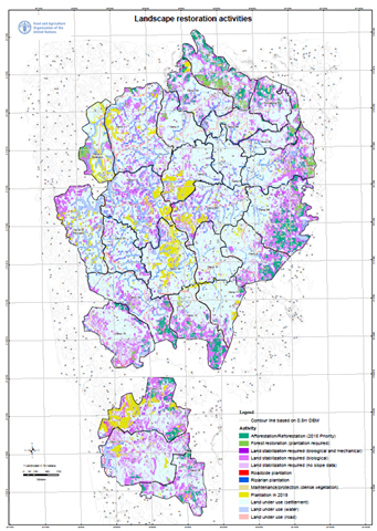 Figure 1: Land suitability assessment in support to planning Landscape restoration activities in Cox's Bazar, Bangladesh
FAO, in close collaboration with WFP and Government partners has been providing timely and local specific information on flood impacts and emergencies in agriculture by combining and integrating different remote sensing and field information in various countries such as Mozambique (Figure 2). Building on latest technological advances, information on population, land use and land cover, crop type datasets, infrastructure information have been integrated with latest imagery to produce impact assessments.
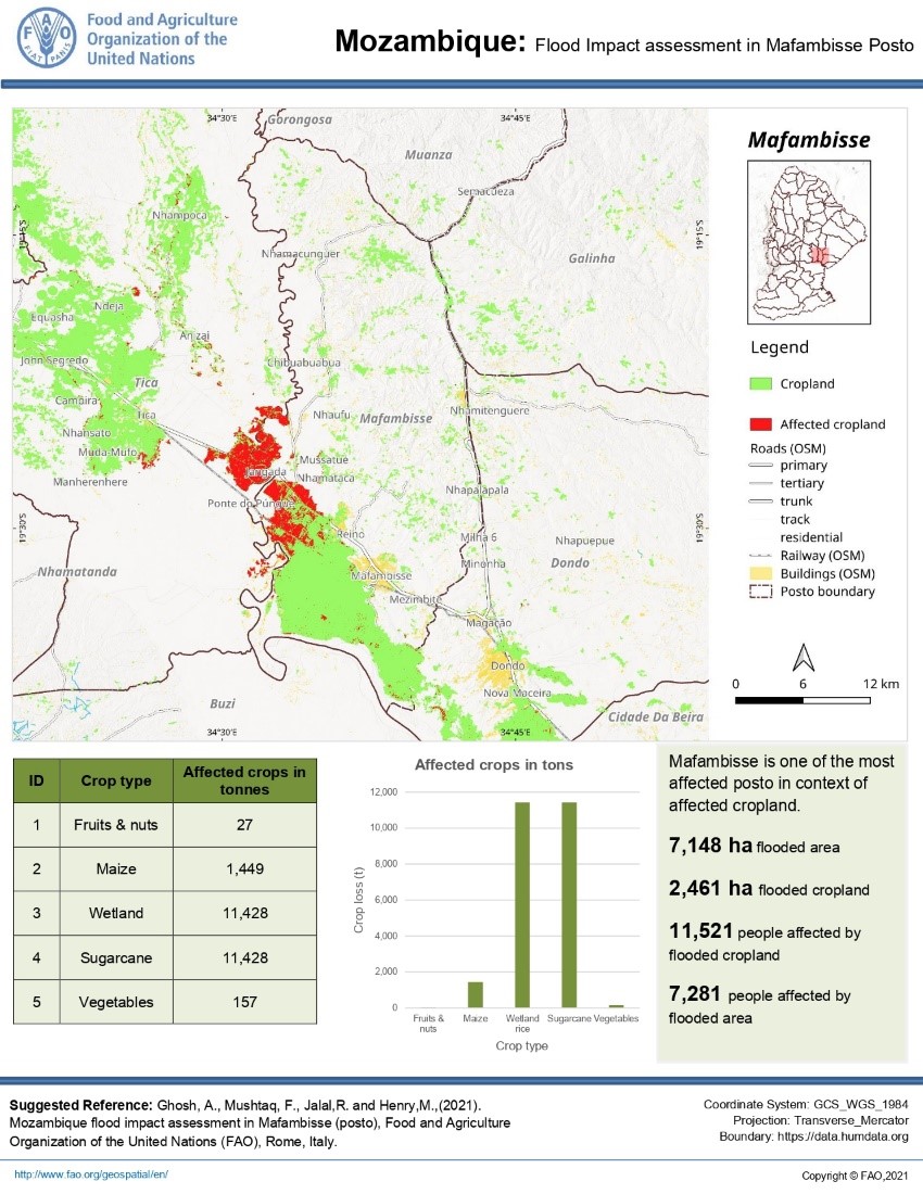 Figure 2: An example of flood impact assessment in Mafambisse, Mozambique at posto administrative level after Eloise cyclone in 2021.
Agro-Ecological Zoning has been adopted by multiple countries as a framework for agricultural development and planning. Building on latest space-related technologies, data and models, various datasets on soil, land, water, vegetation as well as statistics, are integrated to produce agro-climatic analysis, modelling crop performances and yield gap analysis at global to local levels considering climate change scenarios. While the Global Agro-Ecological Zoning platform has been developed by FAO, IIASA and ESRI, FAO and AIT develops free and open-source applications in support to national and local applications, as illustrated through the collaboration with the Ministry of Agriculture and Forestry (MAF) and the Ministry of Natural Resources and Environment (MONRE) in Lao PDR.
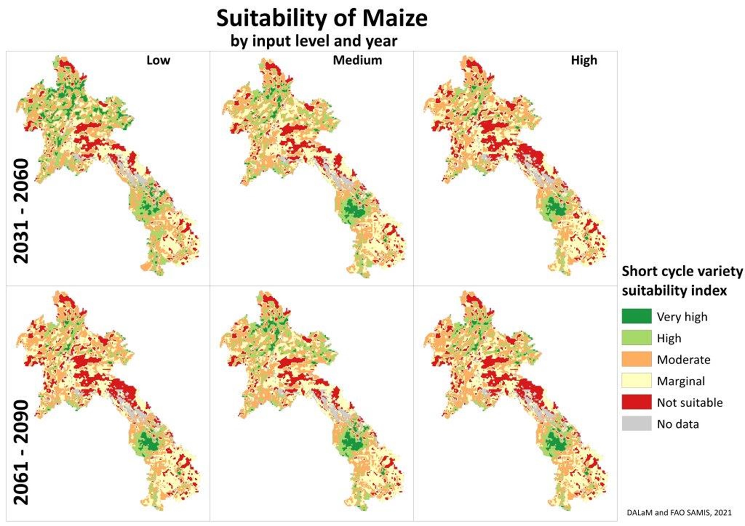 Figure
3
: Land suitability analysis for maize by input agricultural input levels in Lao PDR for 2031-2060 and 2061-2090 considering climate change scenarios.
Figure
3
: Land suitability analysis for maize by input agricultural input levels in Lao PDR for 2031-2060 and 2061-2090 considering climate change scenarios.