Climate Action
Space Technologies and Applications
Earth Observation
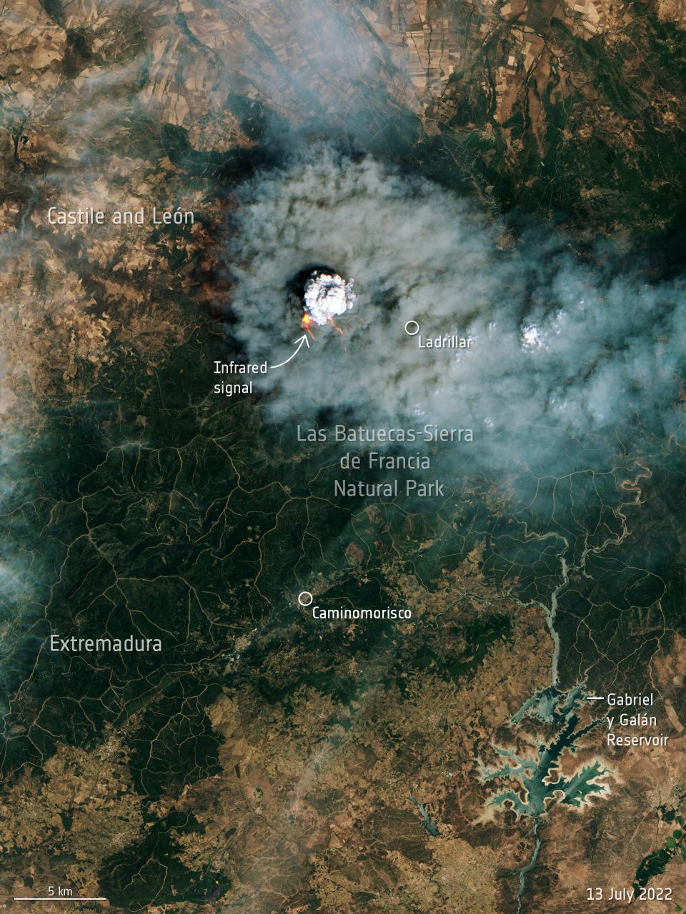
Example of a wildfire near Salamanca, Spain, captured by Sentinel-2. Credits: ESA
Earth observation satellites are by far the most impactful space technology for climate action. Earth observation satellites use remote sensing capabilities (long-distance detection of the physical characteristics of a system through radiation emission and reflection) to capture images of the Earth or gather other types of data about the atmosphere or about Earth's surface. As of 2022, there are about 172 satellites currently being used by the Committee on Earth Observation Satellites ( CEOS) as part of Earth observation programs.
Most Earth observation satellites operate from low Earth orbit (LEO), at about 500 km of altitude, where they are close to Earth's surface relative to other orbits. This is beneficial in terms of distance between the sensors and their target, and in terms of mission cost and complexity, at the expense of global coverage and lifetime. They are sometimes operated as part of satellite constellations and often positioned in polar orbits to iteratively provide global imagery as Earth rotates below them, despite their narrow instantaneous coverage. Many Earth observation satellites - weather satellites especially - are also launched to geostationary orbit (GEO), at about 36,000 km of altitude, for their constant positioning relative to Earth's surface and their very extensive coverage.
The performance of these sensing capabilities is typically characterized by the spatial resolution ("pixel size") obtained, the spectral resolution (the specific wavelengths of electromagnetic radiation captured) and the temporal resolution (how often a location is imaged). Spatial resolutions are typically from below a meter to a few dozen meters. Spectral resolution can be very diverse depending on the objective, but many satellites cover the visible spectrum (between 400 and 800 nm). Temporal resolutions are also very diverse, but often in the order of magnitude of a few days.
Through their sensors, Earth observation satellites can capture a lot of valuable data: temperatures, atmospheric pressure, ocean and land color changes, greenhouse gases and aerosol concentrations, ocean currents, fires, hurricanes, storms, and much more. Applications of these measurements contributing to climate action include: climate monitoring and modeling, tracking sources of pollution, monitoring biodiversity levels, monitoring oceans, fires, floods, agriculture, or land-use.
Satellite Navigation
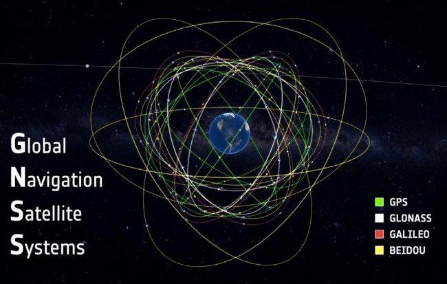
Credits: ESA
Global navigation satellite systems (GNSS) provide geospatial positioning (latitude, longitude, elevation) to users on Earth.
This capability is usually ensured by constellations of 20 to 30 satellites in medium Earth orbit (MEO) at around 20,000 km above Earth's surface. By combining the signal emitted from at least four satellites, and thanks to atomic clock time precision, relativity theory and trilateration techniques, a user's device can provide the time and location with a precision of a dozen meters up to a few centimeters.
Four constellations are currently able to provide global coverage: BEIDOU (China), GALILEO (European Union), GLONASS (Russia), and GPS (United States of America).
Geospatial positioning is an important capability for climate action as it is used to map areas on Earth and track changes (such as ice mass levels, or ground levels). It is also an enabler of numerous technologies important to mitigate causes of climate change or adapt to its consequences, from logistics networks to city mapping and agriculture optimization. Less frequently, satellite navigation can be used to measure pressure, temperature, as well as water vapor levels, as these atmospheric properties affecting the propagation of the navigation signal.
Satellite communication
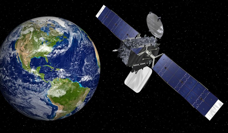
MEXSAT Bicentenario Communication Satellite, a Mexican government-owned communication satellite
Satellite communication makes the establishment of communication channels between two or more sources and receivers at different locations on the planet, with little to no reliance on local ground infrastructures, possible.
By transmitting the signal to and between satellites orbiting Earth, one can exchange information with a receiver beyond the curvature of the Earth. For this reason, communication satellites generally function as part of satellite constellations made of several satellites - up to several thousand - depending on orbits and power capabilities.
These communication constellations operate at very specific electromagnetic frequencies to avoid interference with each other and with other signals on Earth. This also ensures good signal performance despite the attenuation due to the long distance between antennas and the absorption by the atmosphere.
Historically, most communications satellites were deployed in geostationary orbit (GEO) - about 36,000 km away from Earth - in order to have a fixed position relative to ground antennas. More and more, communications satellites are being deployed in low Earth orbit (LEO) - less than 2,000 km away from Earth - as part of much larger constellations made of smaller satellites.
Communication satellites are important space-based capabilities for climate action.
First, they are key for emergency response: as extreme weather events become more intense and more frequent, the ability to communicate with any affected area where ground communication infrastructures may be damaged or overloaded becomes extremely important.
Beyond satellite telephones, satellite internet allows for access to much more information, logistics, imagery and resources to address a crisis locally. Additionally, communication satellites are used to gather data from a multitude of environmental sensors, such as weather stations in very remote areas (oceans, poles, etc.), to monitor climate change and improve current models.
Space Exploration
Space exploration "covers the broad range of technologies associated with enabling successful activities in space, from mission operations to in-situ resource utilization" (NASA, 2020) and, for this website, exploration and research of the solar system, including human spaceflight, and the data acquired through such efforts. A study by André et al. (2021) found that space exploration is relevant to and contributes towards SDG 13: Climate Action, and a separate report by the International Space Exploration Coordination Group (2013) identifies three categories of benefits from space exploration.
Innovation: As scientific research and development are conducted over the course of space exploration, technologies developed in the process assist in responding to and addressing climate change. For example, water processing technology on the International Space Station has been used on Earth in places with scarce access to clean water. Research and development into solar panels for satellites contribute to boosting the efficiency of solar cells and the development and deployment of solar panel farms on Earth.
Culture and inspiration: When people see planet Earth from space, they often refer to the Overview Effect - a shift in cognitive perception of Earth as a rocky ball adrift around the Sun, accompanied by a newfound appreciation for its wonders. The famous Earthrise image captured by NASA's Apollo 8 mission in 1968 boosted the environmental movement. Pictures from space form the basis for understanding climate and provide insight into the fragility of Earth. Space exploration inspires the next generation of scientists, engineers, and social scientists.
New means to address global challenges: Space exploration as a global endeavour builds trust and facilitates diplomacy between space agencies, nations, and regions. This creates new opportunities for addressing global challenges. For example, NASA and the European Space Agency signed a statement of intent in 2021 to work together on climate action [ESA, 2021a); a China-France oceanography satellite was jointly developed to model and tackle climate change (CGTN, 2023); and TRUTHS is a climate focused satellite mission led by the UK Space Agency in partnership with several European states and the European Space Agency (ESA, 2021b).
References:
- CGTN. (2023). UN-China Space Workshop: China-France satellite project providing data on tackling climate change. Available at: https://news.cgtn.com/news/2022-11-23/VHJhbnNjcmlwdDY5NjYx/index.html.
- ESA. (2021a). ESA and NASA join forces to understand climate change. Available at: https://www.esa.int/Applications/Observing_the_Earth/ESA_and_NASA_join_forces_to_understand_climate_change.
- ESA. (2021b). TRUTHS shapes up. Available at: https://www.esa.int/Applications/Observing_the_Earth/TRUTHS/TRUTHS_shapes_up.
- NASA. (2013). Benefits Stemming from Space Exploration. Available at: https://www.nasa.gov/sites/default/files/files/Benefits-Stemming-from-Space-Exploration-2013-TAGGED.pdf PDF.
- NASA. (2020). Technology taxonomy. Available at: https://techport.nasa.gov/view/taxonomy.
Technology transfer
Credits: ESA
Technology development and transfer play two vital roles: addressing the challenges that climate change poses to nature and people, and identifying and enabling opportunities for developing new solutions. In 2008, the United Nations Framework Convention on Climate Change (UNFCCC) and its parties agreed to facilitate, promote and finance environmentally friendly technology transfers. Furthermore, the agreement included know-how to developing nations and assistance in reducing the vulnerability of the developing world through achieving adaptation costs. With regards to technology development and transfer for addressing climate change, United Nations entities collaborate with other international organizations, governments, and nongovernmental entities, as highlighted by A Survey of Activities by United Nations System Organizations on Technology Development and Transfer for Climate Change, has been focusing on the following bulletins:
-
"Providing more comprehensive information on technologies, commercial products, techniques and methods;"
-
"Creating a global programme of accelerated public and private investment to rapidly increase capacity of renewable energy systems in conjunction with effective policy mechanisms as a means to sharply reduce costs and motivate technology improvements;"
-
"Promoting national and regional markets for ESTs and adaptive technologies, especially with an environment that will foster local production;"
-
"Enhancing the emphasis on the promotion of the development of comprehensive national plans that integrate issues of climate change with those of the environment, sustainable development and achieving the Millennium Development Goals;"
-
"Increasing the number of programmes that provide fully integrated technical assistance to help develop, manage and operate EST projects and/or businesses;"
-
"Augmenting the number of projects that involve enterprises, such as through joint ventures, for transferring, deploying and developing ESTs;"
-
"Increasing efforts that result in capacity-building through joint research involving researchers from developing nations in institutions of developed and developing countries."